|
The following is
an article penned by world henge expert and anthropologist Ronald
Hicks, of the Department of Anthropology at Ball State University,
Indiana, USA.
It seems to me that certain issues important for understanding the
opposition archaeologists and other scholars have displayed toward the
M3 highway project have not really been clearly explained in the debate
so far.
|
From what I have read in the newspapers, it is apparent that
the public, and perhaps even those in the government, have a rather
limited and out-of-date conception of just what archaeology is all
about. This is probably the fault of archaeologists, for we do tend to
be rather too involved in talking to each other rather than
communicating as we should with the public, who in the end provide most
of the support for our work.
|
|
Consequently, I will try here to clarify
1) the objectives of
archaeology,
2) the reason for our concern with "landscape" rather than
just sites, and
3) what is today considered good archaeological
practice.
If I succeed, it will also clarify the vehemence of our
objections to the planned highway routing.
Many seem to think that the goal of archaeology is to retrieve
artifacts, and the more spectacular the artifact, the better. This is
simply not the case. An artifact in and of itself has little value for
archaeology, although it may make for an interesting museum display.
What is of utmost importance is information. For archaeology, this
comes in four major types of data that must be recovered and analyzed:
artifacts (things--usually portable--made or modified by humans),
features (modifications to the site itself--monuments, pits, hearths,
post-moulds, etc.), ecofacts (floral and faunal material ranging from
pollen to charcoal to animal bones that provide evidence of the local
environment, human use of it, and the date of that use), and, probably
most important of all, context (the relationships among all of the
other sorts of data and between the site itself and the surrounding
landscape).
What are archaeologists trying to do with these data? Four broad
objectives are now widely recognized. The first, and oldest, is that
archaeologists are expected to reconstruct culture history (the
sequence and chronology of cultures). Once one knows what culture
belongs where in time (and geographically), the next step is to
reconstruct that culture--their way of life--as fully as possible. That
will then allow us to gain some understanding of the culture process
(i.e., why things were done as they were and why they changed, or
didn't). Finally, and most difficult of all but certainly vital for a
sacred site such as Tara, we must try to gain some understanding of the
way the people of the past thought about their world (their religion,
cosmology, ideology, iconography, and so on).
From the last of the types of data listed above, context, you
should begin to suspect the reason for our concern with the landscape
beyond the site. While archaeologists used to focus solely on sites,
over the past few decades they have come to realize that sites do not
exist in isolation and that their creators did not think of their world
primarily in terms of their house or village. People do not simply
occupy a structure, a farmstead, or a village; these have meaning only
within the larger landscape.
Significant places in a prehistoric landscape may actually be natural
features that contain no evidence for human activity. For example, a
hilltop--and plenty of those besides Tara and Skreen are mentioned in
Irish myth--may be seen as the dwelling place of a god. Ritual
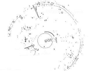
complexes, of which Tara is the premier example from later Irish
prehistory, typically cover an area of several square kilometers within
which are found a cluster of monuments recognized as being of a ritual
or ceremonial nature--passage tumuli, earthen enclosures, and so on--as
well as a variety of lesser elements that are nonetheless important. To
the people of the past, they would have been seen as a unit. The
complex surrounding Newgrange, for instance, covers approximately 16
square kilometers. That at Tara undoubtedly includes Rath Maeve, whose
far edge lies 1.6 km to the south, and the Riverstown enclosure and
linear banks lying nearly 2 km to the west and northwest. The northern
and eastern limits are less clear, which of course means we have less
information in precisely the area to be affected by the proposed
highway. In my own professional opinion, it is nonetheless highly
likely that the complex incorporated elements at least 2 km to the
north and east, such as Rath Lugh. To the east the closest prominent
feature that might have marked a boundary to the district is, in fact,
the Hill of Skreen, some 3.4 km away, well within the likely limits for
such complexes. The presence on that height of an early monastic site
is another indication that it is likely to have been a pre-Christian
sacred site and thus part of the complex.
To turn to the issue of methodology, the use of 22-tonne mechanical
excavators in stripping topsoil to expose archaeological features is,
at best, highly questionable. Stripping the topsoil is acceptable only
if there is strong reason to believe that any deposits in that layer
have been thoroughly disturbed--through long-term plowing, etc.--and
even then it is not a good idea because experimental work has shown
that plowing tends not to move things very far, meaning that one can
still learn from the material in the topsoil. If such stripping is
done, great care must be taken not to disturb deposits below that
depth--which is difficult given the damage the earth-moving equipment
itself is likely to do just by virtue of its weight, particularly the
large machines they are using. In any case, a representative sample of
the removed soil should be screened to determine what, if any,
artifactual or other data it may contain.
Furthermore, while rapidly removing recent historical deposits to get
to the "real archaeology" underneath was considered acceptable to many
three or four decades ago, it certainly is not now. There is just as
much to be learned from those layers as from older ones, because
documents and the history books are very selective in what they record.
Carrying out an archaeological excavation is comparable to performing
medical experiments on animals. One often has to destroy the subject to
recover the data. Archaeology is by its very nature highly destructive.
And any data not recovered in the process are lost forever. As a
result, modern archaeologists dig only when essential and typically
only in a limited portion of a site--no more than is necessary to
answer the particular research questions that are of interest at the
moment. Not only data bearing on those questions but also all other
recognizable data must be collected and recorded.
The reason for this limited approach to excavation--and
increasingly heavy reliance on remote sensing--is that we have learned
over the past century or so that our ability to recover information
continually improves. What appeared to be useless material to an
excavator a hundred years ago, fit only for the spoil heap, we now know
to have contained information vital to our understanding of the sites.
A simple example would be charcoal. Who in 1907 would have thought that
a few grams of charcoal held the key to dating a site? What early
investigators of caves in France took to be waste flakes from tool
production, we now know to have been utilized as tools themselves in
many cases. Edge-wear analysis using high-powered microscopes simply
did not exist. Nor could we recover DNA of the animals or plants being
processed from residue in the pores of the stones, as is often the case
now.
Unfortunately, highway projects such as the M3 do not allow us to
preserve parts of the sites for future excavators. And the additional
information the sites undoubtedly contain will not be recovered because
we do not yet know what to record, recover, or preserve, so it is
permanently lost. The thirty-eight sites that are said to lie in the
path of the highway through the Gabhra Valley represent a very large
potential loss of information about the Tara complex. The much touted
"preservation by record" is an illusion.
I hope the above comments provide a bit more context. If any readers
have questions or require additional clarification, I can be reached at
rhicks@bsu.edu or Ronald Hicks, Department of Anthropology, Ball State University, Muncie, Indiana 47306, USA.
|
