|
source - http://www.nuigalway.ie/archaeology/Tara_RoadsIreland_07.html
A rear-view perspective of Tara from the M3
for Roads Ireland magazine – (forthcoming December 2007)
Joe Fenwick, Department of Archaeology, NUI Galway.
Tara retains a unique cultural resonance for Ireland and for people of
Irish descent throughout the world. Though its archaeological legacy is
of enormous significance, it is the wealth of early historical,
mythological and legendary sources associated with Tara in addition to
its singular importance to Irish language, folklore and place-names
studies that truly sets this place apart. According to some of the
earliest literary sources, Tara was chief amongst the ancient
prehistoric royal centres of Ireland, serving as a major ritual
sanctuary before (and after) the coming of Christianity, a place of
royal inauguration and the seat of the high kings of Ireland. Indeed, a
number of these documents record that Tara, in recognition of the
central political and symbolic role that it continued to command well
into the historic period, was the central focus of five major roadways
(the Slige Asail, Slige Chualann, Slige Dála, Slige Mór and Sligh
Mudlúachra) which were said to have radiated to the furthest reaches of
the Island. Over the intervening centuries the political focus has
shifted and today all roads lead to Dublin; like the spokes of a great
lopsided wheel converging on the M50. Of these spokes, three major
motorways (the M1, M2 and M3) will traverse Meath. The one currently
under construction, the M3, will bisect the royal demesne of Tara.
Tara has been the focus of State-funded archaeological and
historical research since the Discovery Programme was founded in 1992.
This work has yielded a wealth of new and exciting material, the
results of which are published in numerous peer-reviewed articles and
books (e.g. Conor Newman’s book Tara , An archaeological Survey
published in 1997 and Edel Bhreathnach’s edited volume entitled The
Kingship and Landscape of Tara published in 2006, to name but two). The
significance of Tara’s archaeological and historical landscape is
undisputed amongst scholarly and academic circles; indeed it was
recognised as such long before the current route for the M3 motorway
was chosen as the ’preferred route’ option. It has been demonstrated
conclusively, both archaeologically and historically, that the cluster
of unusual earthworks on the hilltop of Tara is but the nucleus of a
well-defined, integrated complex of archaeological monuments extending
into the surrounding landscape, a place universally acknowledged as one
of Europe’s foremost cultural landscapes. In an unbroken ritual
continuum over the millennia, the Hill of Tara has served as a
necropolis, ritual sanctuary and temple complex. This, in turn, served
as the backdrop to ceremonial pageantry and royal inauguration which
was to continue well into the Early Medieval period, long after its
religious authority had been supplanted by Christianity.
From humble origins as a passage tomb cemetery (dating to the
second half of the 4 th millennium BC) its importance grew with each
successive generation to reach its zenith during the Iron Age – at a
time when most of Britain and Europe was under Roman domination. In its
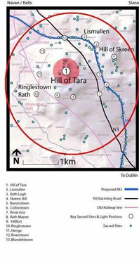
immediate hinterland are the physical remains of related prehistoric
barrows, cemeteries and ritual sites - such as the series of earthen
mounds in the Gabhra valley, the barrow cemetery of Skryne, the unusual
cemetery of mixed burial tradition at Collierstown (some 2000m to the
southeast of the Hill), the vast embanked enclosures of Rath Maeve and
Riverstown (situated 1600m and 1000m to the south and west of the
hilltop summit respectively), or the post-built ceremonial enclosure
with central temple at Lismullin (1600m to the northeast). The common
settlements and high-status royal residences of those who lived in its
shadow, who worshiped and ruled over Tara, were kept remote from the
hilltop sanctuary. It appears, therefore, that Tara is quite literally
a necropolis, a ’city of the dead’, and not a citadel as some had
speculated. The complexity of conjoined enclosures noted from aerial
photography at Belpere, for instance (situated approximately 800m to
the southeast of the hilltop), or the extensive multi-period earthwork
remains at Baronstown (lying midway between the Hills of Tara and
Skryne) are likely to represent the remains of high-status settlements.
At some stage in late prehistory the western and northern limits of
this broader surrounding hinterland were more clearly demarcated by a
series of defensive earthworks and fortifications. The remains of a
substantial double-banked linear earthwork, situated about 1000m to the
west of the Hill of Tara, can be traced for a distance of some 1600m.
Reinforcing this defensive earthwork is a semi-circular array of
equi-spaced fortifications (among them Ringlestown Rath, Rathmiles and
Rath Lugh) strategically placed to defend the western, northern and
northeastern flanks of the Hill and control passage through the Gabhra
valley. Together these monuments define a buffer-zone defending what
was, at this stage, a major political, religious and symbolic powerbase
from potential military incursion from the north. By the Early Historic
period (from around the 6 th century AD) the limits of this zone had
become more formally defined as the ferenn rí, or royal demesne, of the
kings of Tara. As if proof were needed of the significance of the
Gabhra valley and the connection between the Hill of Tara and its
sister hill of Skryne, a charter dating to AD 1285 mentions the
existence of a ’royal roadway that goes from the manor of Skryne to
Tara’ ( regalem viam qua itur de villa de Scryn versus Taueragh).
Tara retained its pre-eminent political role as ’caput Scotorum’
(capital of the Irish) and centre of kingship in Ireland throughout the
first millennium AD and beyond. For this reason it continued to serve
as the backdrop to major political and military upheavals up until the
present day. In AD 980, for instance, the battle of Tara witnessed a
decisive defeat for the Vikings of Dublin at the hands of the Southern
Uí Néill king, Máel Sechnaill II. As late as 1170 Roderick O’Conor was
inaugurated here as high king of Ireland. In more recent centuries,
Hugh (The Great) O’Neill was said to have rallied his troops on Tara
before marching to engage in battle at Kinsale in 1601. Again the
hilltop was chosen – as much for symbolic as strategic reasons – as the
location for a military engagement with crown forces during the 1798
rebellion. It was also the setting for one of Daniel O’Connell’s
monster meetings in August 1843, said to have been attended by a
million people. It is this fascinating convergence of tangible
archaeological remains illuminated by a very significant corpus of
historical documents and the extraordinary and pivotal national events
which unfolded here that sets this landscape apart. It is for this
reason also, that it is entirely inappropriate to build a four-lane
motorway and major floodlit interchange through it.
copied from - www.mythicalireland.com
|