download the original pdf - |
|
| " The Elusive Iron Age" - download article - |
|
M3 Clonee - Kells Motorway Project
Information on Archaeological Investigations at Lismullin, Co. Meath
A008/021 & E3074.
Summary
Archaeological investigations have been undertaken for the almost two years on the approved M3 Clonee –North of Kells motorway scheme(fig 1-2), in accordance with Directions issued by the Minister for Environment, Heritage and Local Government under the National Monuments Acts. This work was recently completed with the exception of a site at Lismullin, Co. Meath, which the Authority has concluded is a National Monument. The Authority’s discovery of the site has been reported to the Minister as required by legislation. Both the Chief Archaeologist of the Department of Environment, Heritage and Local Government (DEHLG) and the Director of the National Museum visited Lismullin as soon as the Road Schemes Archaeologist became aware of the potential significance of the site. The Authority has ceased all works at the National Monument pending the Directions of the Minister.
The enclosure is presently undated. However preliminary investigations indicate that it is most similar in morphology to late prehistoric ritual enclosures dating to the Late Bronze Age/Iron Age. Its closest parallels are phases of the royal sites of Emain Macha, Co. Armagh and Dún Ailinne, Co. Kildare, although Lismullin is of a much smaller scale, is much less complex and appears to represent a single phase of use. Archaeological excavation has revealed that the enclosure at Lismullin has been heavily truncated by past centuries of ploughing, with the result that the sample of surviving features investigated to date are very shallow.
Location
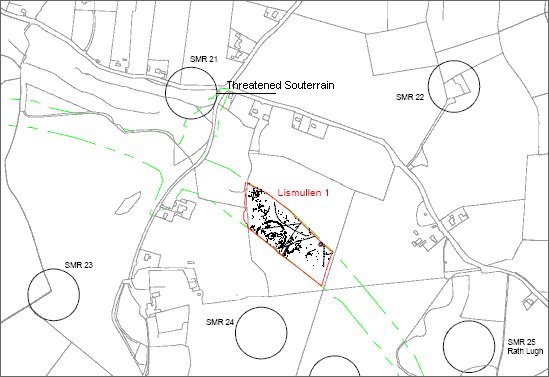
The site is located in the townland of Lismullin (NGR E293424 N261564) beneath the Hill of Tara in the Gabhra Valley, close to the Gabhra River. The topography of the valley is characterised by glacial features including eskers and gravel ridges. The site itself is situated at the centre of a natural geomorphological hollow surrounded by a ridge of higher ground which overlooks all sides of the monument, which in turn is surrounded by lower ground (Fig 3).
1
Preliminary Description
The site is a large (c.80m diameter) circular enclosure formed of a double row or ring of stakeholes. The two rows are c.2m apart. The stakeholes are small in diameter (c.10-15cm) and evenly spaced (c.60cm apart) perhaps suggesting post and wattle construction. The enclosure appears to have an entrance in the east. A smaller enclosure c.16m in diameter formed of similarly closely spaced postholes (c.25cm diameter) is positioned centrally within the large enclosure. There are two radial rows of postholes forming a corridor between the entrance of the outer and inner enclosures. In addition there are what appear to be two slot trenches between the end of the corridor and the entrance of the inner enclosure (Fig. 4.).
The enclosure is situated at the centre of a natural geomorphological hollow surrounded by a ridge of higher ground which overlooks all sides of the monument, which in turn is surrounded by lower ground. A portion of the enclosure extends beyond the limit of the CPO landtake edge.
Only two artefacts have been recovered in the vicinity of the enclosure to date, neither of which are stratigraphically related to the enclosure – a small shale adze or axe and a sherd of middle bronze age pottery. In addition a ringed pin, which appears to be of late Iron Age date, was recovered from a feature outside the enclosure.
In agreement with the DOEHLG and the National Museum of Ireland a small selection of stakeholes in the outer enclosure were excavated and their fills are being processed in order to extract sufficient charcoal for scientific C14 dating.
Significance and Parallels
In terms of morphology - the exact central positioning of the inner enclosure, the large size of the outer and inner enclosures and the radial entrance corridor – the closest parallels suggest that this site may be a ritual enclosure – dated to the Late Bronze Age or Iron Age. The Lismullin site can be compared with a number of Late Bronze Age and Iron Age enclosures.
At the hilltop Iron Age royal site at Dún Ailinne, Co. Kildare, one of the phases (the second or ‘rose’ phase) consists of a series of closely spaced circular timber enclosures, formed of deep foundation trenches 27m-31m in diameter, (which may be contemporary or successive), with a funnel shaped timber avenue which extends towards the entrance of an outer ditched and banked enclosure, 400m in diameter.
The central enclosures were annexed to the south by a series of smaller enclosures forming a figure-of-eight enclosure.
At Emain Macha, Co. Armagh, the Iron Age Phase 3ii structures provide another parallel. This phase consists of a complex sequence of circular timber structures formed of palisade trenches c.20-25m in diameter, with an entrance to the east and a sequence of parallel trenches forming a corridor or avenue out towards an outer ditched enclosure, 286m in diameter. As at Dún Ailinne, the inner enclosure is annexed by a smaller enclosure (c.10m-13.5m in diameter) to form figure-of-eight enclosures.
Geophysical surveys at Rathcroghan Mound, at the centre of Cruachan, Co. Roscommon have revealed a series of possible palisaded circular enclosures, c. 17m and 30m in diameter, centred within a 90m diameter embanked enclosure which may be enclosed within a palisaded circular enclosure, 120m in diameter. A number of linear anomalies perpendicular to the eastern edge of the inner enclosure may represent an entrance avenue or corridor as present at Emain Macha, Dún Ailinne and Lismullin.
At Raith na Senad on the Hill of Tara, the second phase consisting of a series of palisaded enclosures c.16m and 25m in diameter (potentially situated within a much larger, but as yet undated, enclosure recently identified by geophysical survey) may also provide a parallel.
Closer in scale to Lismullin, but again of different construction, is the Iron Age phase of Raffin Fort, Co. Meath. Here a 9m diameter circular slot trench with an eastern entrance is centrally situated within a 65m diameter circular ditched enclosure with an external bank. There is no evidence of a corridor between the internal and external enclosures. Raffin Fort has been interpreted as an Iron Age ritual complex or site associated with a lower grade of political power than those represented at Dún Ailinne, Emain Macha and Rathcroghan above. Other later prehistoric sites in Ireland have produced circular features situated centrally within wider ditched enclosures such as those at Rathgall, Co. Wicklow, which are dated to the Late Bronze Age.
In addition to the differences in scale and construction methodology (i.e. stakeholes rather than ditches and banks in the outer enclosure and small shallow postholes rather than deep foundation trenches) the site at Lismullin has a number of other distinct differences from these parallels (Fig 5). The low-lying position of the site is at variance to the above parallels which are all located on hilltops. Lismullin while not located on a hilltop, is situated at the centre of a natural geomorphological hollow and therefore higher ground overlooks all sides of the monument. The enclosure is likely to have been deliberately situated to take advantage of this unusual natural topography, which will add to the interpretation of its use. The Lismullin enclosure also differs from a number of the above parallels in that they have multiple phases of rebuilding, while the enclosure at Lismullin appears to represent a single phase of use.
In addition unlike the Lismullin enclosure the parallels outlined above are phases of sites that have multiple phases of construction and long-term use spanning millennia.
Dating and Interpretation
Lismullin remains scientifically undated and it should be noted that large enclosures defined by upright posts can be dated to other periods, particularly the Late Neolithic and early medieval period. Considering some of the differences between Lismullin and the Late Bronze Age/Iron Age sites described above, it is possible that the site at Lismullin may have a different date and function to the above parallels. However, the basic similarities (i.e. an inner circular feature, a larger outer enclosure and a corridor feature) mean that Lismullin is a convincing candidate for a Late Bronze Age/Iron Age ritual enclosure.
The site’s location beneath the important ceremonial complex on the Hill of Tara may suggest that this is a ceremonial site serving smaller or lesser political units. It may perhaps be more directly related to the nearby cliff top fort Rath Lugh. It may alternatively represent a single ceremonial event on a site which was not then used again, unlike the parallels described above
4
Condition
Prior to excavation, there were no visible archaeological features of this site. The site was discovered in the course of topsoil stripping (in accordance with Ministerial Directions) and is now uncovered, within the landtake. Archaeological excavation has revealed that the site has been heavily truncated by past centuries of ploughing, with the result that the sample of surviving features investigated to date are very shallow. The site is exposed and is vulnerable to deterioration, however as a temporary measure the features have been protected with plastic and the site is secured. During very wet weather however the site will be susceptible to hill wash and silting due to its low position beneath a gravel and sand ridge.
Other Sites
A series of smaller sites and dispersed features ranging in date from middle bronze age to early medieval are dispersed across the large cutting in which the enclosure is located and excavation of many of these has been completed.
Excavation is ongoing of an early medieval souterrain which is located approximately 50m from the enclosure. This souterrain is not related to the enclosure.
Construction
Construction of the approved M3 Motorway Project is underway. The Contractor Eurolink has been informed of the status of the Lismullin enclosure site. No construction work will take place at this location pending the outcome of the Ministers deliberations and any requirements he may impose under Direction under the National Monuments Acts.
Road construction activity of the approved M3 route, with the exception of the Lismullin enclosure site will proceed as planned.
5